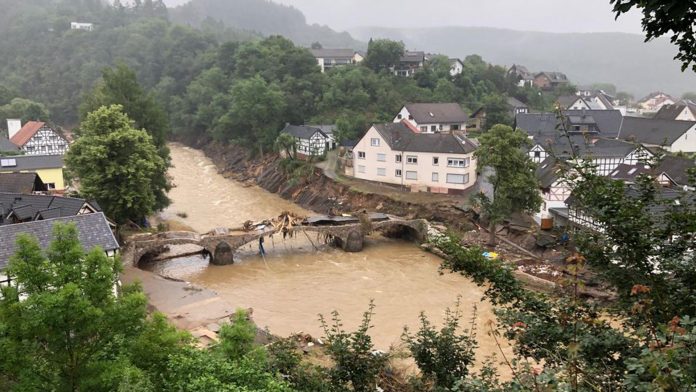
RSS-Hydro emphasises the importance of considering flood vulnerability when devising flood prevention strategies.
Floods are the most common natural hazard in the world. Globally, 1.47 billion people are exposed to this phenomenon.1 All of the continents are concerned, even though the dynamics involved differ (pluvial floods, fluvial floods, rising groundwater flooding, ocean flooding during meteorological extremes, etc.). Recent events in Europe, Brazil, South Africa, and many more areas have highlighted the importance of flood risk management and preparedness. This is even more the case under climate change, which seems to widen the affected areas and amplify event frequency in general,2 while urban areas keep developing and gaining territory.3
The definition of risk and its components
When analysing a natural risk, be it floods, hurricanes, landslides or other, it is important to look at all of the components that form a ‘risk’. It is commonly known that a risk is a combination of a hazard and the exposure of people, buildings, and networks (transport, communication), that are at stake and that are more or less vulnerable.4
The differentiation between exposure and vulnerability is especially visible in the case of flooding. A house being exposed to floods because of its location in a flood-prone area does not necessarily mean that it is vulnerable. In this article, we examine this difference more in detail to help better understand exposure and vulnerability to floods.
Analysing exposure based on flood models
To analyse exposure, it is essential to have an accurate flood model that allows us to identify a flood-prone area. This can be challenging depending on the area of interest and often limited data. Many companies and research groups try to overcome the lack of available data. The SEMOR project, led by RSS-Hydro with national and local partners, is such an example, in which the aim is to develop a flood model across the Niger River Basin that allows regional and national water resource managers to better understand flood exposure in the Sahel countries.
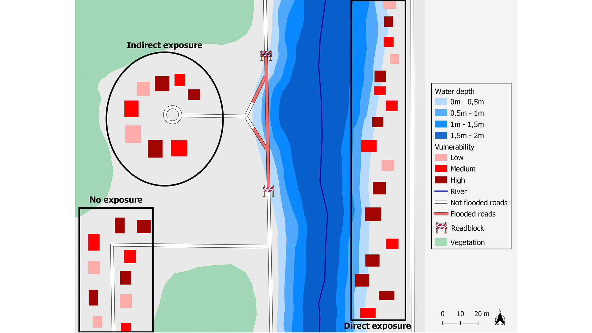
It is generally understood that exposure can be divided into direct and indirect exposure.5 Direct exposure is the spatial coexistence of a hazard and people, constructions, or infrastructures that are located in that area (Fig. 2). This type of exposure can generally lead to physical and mental harm, material loss and financial loss, while indirect exposure is linked to the consequences of a flood that go further than the flooded area itself. An area can be impacted by a flood, even though it is not actually flooded.6 This can be the case in a rural area, for example, where a flood can make an area completely inaccessible (Fig. 2). Another example of an indirect exposure is the inability for people to access their worksite, which has repercussions on productivity and income.
Major differences in flood vulnerability
Exposure to floods has a negative impact on vulnerability because it can lead to the previously listed impacts. However, vulnerability is a much more complex system, that is not only based on exposure. It is often defined as a probability of damage to exposed assets that are relevant to a society.4 Impacts on people, houses, companies, cities and networks (roadway, railway, wire network, etc.) are not all equal when exposed to flooding. There is also geographical variation and differences in the social, architectural, and political standards of an area. Therefore, the vulnerability assessments and the methods used should be adjusted according to those elements.

When it comes to the vulnerability of people, taking into account demographic characteristics is key. One of the major difficulties for people that live in a flooded area is getting to safety without being injured or swept away by flood waters. Half a metre of water depth, at low velocity, is generally considered as a safety limit for a child, whereas for adults this can reach up to one metre.7 This directly impacts children and elderly people, among others, that can be considered more vulnerable than a healthy young adult, for example.
Another important criterion linked to vulnerability of people is their financial capacity, which is strongly linked to resilience. Moreover, there is evidence that natural disasters often seem to point to inequalities and, so, living conditions should also be considered. The materials used, the type of architecture, and the presence or absence of property protection measures all contribute to a building’s level of vulnerability. This criterion also has a very important cultural and financial aspect and varies a lot between countries and continents. Considering all of these criteria is necessary to gain a complete picture of flood risk, given that the impacts of floods are so diverse.
Similarly to people, floods do not affect companies, cities or networks in the same way. Impact depends on the severity of the flood, the type of company, the protection measures in place and the company’s financial capacity to rebuild after a flood. As far as cities are concerned, vulnerability is linked to many factors, such as prevention measures, warning and crisis management capabilities, and financial and human resources. Finally, evaluating the vulnerability of a network to flooding can be far more complex because it needs highly specific technical skills and knowledge. Evaluating, for example, if a bridge can withstand a 100-year flood event can be complex, because it depends on the materials used, the maintenance and the conditions but also the soil formation which the bridge is standing on.
The importance of flood risk maps
Flood risk maps have multiple fields of application. First of all, it is important to take into account flood exposure for city planning. Urbanisation expands rapidly, almost everywhere, and the effects on flood risk are not always considered. However, integrating flood risk maps allows urban planners to develop cities without necessarily increasing exposure to floods or, at least, to prepare compensatory measures in order to keep vulnerability to a minimum. Therefore, mapping floods and vulnerability (Fig. 2) allows for a better understanding of risk and promotes flood risk reduction. The latter is made up of public and private property protection measures on the one hand, and public awareness on the other hand. For this purpose, flood risk maps offer a very effective way of delivering an analysis and communication tool that can be easily understood, as long as they are done properly. Other fields of application are, for instance, crisis and disaster management and insurance, and many more.
References:
1 Rentschler J E & Salhab M (2020) – 1.47 billion people face flood risk worldwide : for over a third, it could be devastating – World Bank: https://blogs.worldbank.org/climatechange/147-billion-people-face-flood-risk-worldwide-over-third-it-could-be-devastating
2 Williams M (2022) – The IPCC Releases its 2022 Report on Climate Change, in Case you Needed Something Elso to Worry About: https://www.universetoday.com/154744/the-ipcc-releases-its-2022-report-on-climate-change-in-case-you-needed-something-else-to-worry-about/
3 The World Bank (2020) – Urban Development: https://www.worldbank.org/en/topic/urbandevelopment/overview
4 Metzger P & D’Ercole R (2008) – Enjeux territoriaux et vulnérabilité : une approche opérationnelle – in : Colloque Vulnérabilité sociétales, risques et environnement. Comprendre et évaluer – Université Toulouse, Le Mirail, 11 p.
5 Leone F, Péroche M, Lagahé E, Gherardi M, Sahal A, Vinet F, Hachim S, Lavigne F (2013) – Modélisation de l’accessibilité territoriale pour l’aide à la gestion de crise tsunami (Mayotte, France), 24 p.
6 Leone F & Vinet F (2006) – La vulnérabilité, un concept fondamental au cœur des méthodes d’évaluation des risques naturels, 17 p.
7 DGPR, CEPRI, CEREMA (Direction générale de la prévention des risques, Centre européen de prévention du risque d’inondation et Centre d’étude et d’expertise sur les risques, l’environnement, la mobilité et l’aménagement) (2016) – Référentiel national de vulnérabilité aux inondations, 128 p.
Please note, this article will also appear in the eleventh edition of our quarterly publication.


