GGE uses high-precision local to global monitoring for geodetic, geophysical, engineering and environmental applications using GNSS, remote sensing and reality capture.
The Research Group Geodesy and Geospatial Engineering (GGE) focuses on problems which enable more sustainability and resilience in view of ever-present societal challenges while contributing to fundamental geodetic infrastructure and method developments.
This, in turn, enables many aspects of our technology-driven society, from monitoring of climate change to communication networks.
High-precision remote sensing to combat climate change
For this the GGE group develops and employs various geodetic and remote sensing techniques, such as Global Navigation Satellite Systems (GNSS), optical and hyperspectral imaging, Light Detection and Ranging (LiDAR) laser scanning, as well as conventional surveying instrumentation to investigate a wide range of applications often related to climate change and the hydrological cycle.
To achieve the research objectives, the GGE group also develops and engages conventional as well as data-driven methods in geospatial data analyses, focusing on high-precision and accuracy, automation and efficiency, and impact.
AREAS OF EXPERTISE
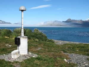
- Global Navigation Satellite System (GNSS) data processing and analyses
- Light Detection and Ranging (LiDAR) data processing and analyses
- Optical and hyperspectral imaging, data processing and analyses
- Algorithm development (mathematics, stochastics, robust statistics, and artificial intelligence)
RESEARCH INTERESTS
- Monitoring of crustal/land/structural movements, deformations and displacements of geophysical, environmental and anthropogenic origins (e.g. glacial isostatic adjustments, mass redistributions, changes in the hydrological cycle or sea level, urban and mining subsidence, ground water extraction, ageing of buildings and infrastructure, and tide gauges).
- Global, national and regional coordinate reference frame determinations and systems, with contributions to global networks of scientific sensor stations and national coordinate reference frame maintenance (datum definitions) and computations.
- GNSS atmospheric sensing for meteorology and climatology (weather fore, and nowcasting, severe events tracking, and long-term atmospheric changes in water content).
- Development of data-driven methods in applications of LiDAR data, optical and hyperspectral imagery (e.g. classification and feature extraction in geospatial big data; crop health and fertiliser optimisation in precision agriculture; tree metrics, tree health, and biomass estimations in forest management).