Resilient cities are built on data: SafeCity provides advanced flood modelling for a safer future.
Urban flooding is a growing threat to cities worldwide, driven by a combination of factors like urbanisation, climate change, and ageing infrastructure. Accurate flood modelling is crucial for effective flood risk assessment, mitigation, and management.
Traditional flood modelling approaches often fall short in capturing the intricate interactions between surface water and drainage systems, leading to inaccurate predictions.
SafeCity emerges as a powerful solution that addresses these limitations. It employs a coupled 1D-2D detailed flood modelling approach, integrating one-dimensional (1D) hydraulic models of underground drainage systems with two-dimensional (2D) surface water models.
This comprehensive approach offers a nuanced understanding of flood dynamics within urban environments.
Benefits of SafeCity:
- Detailed flood risk assessment: SafeCity provides a complete picture of flood risk across an entire city, encompassing individual buildings and infrastructure.
- Integrated drainage network modelling: It integrates the underground drainage network with surface flooding, enabling a thorough assessment of water flow through the system.
- Scenario analysis: SafeCity allows for the analysis of various flood return periods, historical events, and future development plans.
- Flood mitigation measures: The solution generates a comprehensive report with recommendations for flood protection measures.
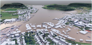
- 3D visualisation: SafeCity offers 3D visualisation of model simulations and scenarios, creating a digital twin of the city.
- Flood forecasting: The model can be run as a forecast tool to predict potential flood events.
SafeCity empowers cities with valuable insights to make informed decisions on flood preparedness and response.
Key applications:
- Evaluation of flood mitigation measures: Assess the effectiveness of various flood control strategies.
- Land use and urban planning: Guide land-use decisions and inform urban planning practices.
- Enhanced urban design: Develop flood-resilient urban designs.
- Risk-informed decision making: Support data-driven decision-making processes for flood risk management.
By leveraging SafeCity’s capabilities, cities can build more resilient and sustainable communities that are better equipped to mitigate the impacts of flooding and safeguard the well-being of their citizens.
Future directions: Advancing flood modelling to new frontiers
While SafeCity offers significant advantages, there are limitations to address. Rainfall predictions from forecast models often require downscaling to finer resolutions for accurate urban flood modelling.
Machine learning-based forecasting models and AI-powered downscaling methods, such as NVIDIA’s FourCastNet, hold promise in this area. Additionally, improved communication of flood risks and enhanced public awareness are crucial aspects.
AI-powered 3D visualisation tools, e.g. NVIDIA’s Omniverse platform, can play a significant role in creating realistic simulations and digital twins of cities, fostering a deeper understanding of flood risks and promoting climate resilience in vulnerable communities.
In conclusion, SafeCity represents a sophisticated flood modelling solution that empowers cities with the knowledge to confront the challenge of urban flooding.
By integrating advanced modelling techniques with a user-centric approach, SafeCity paves the way for building more flood-resilient and sustainable urban environments.