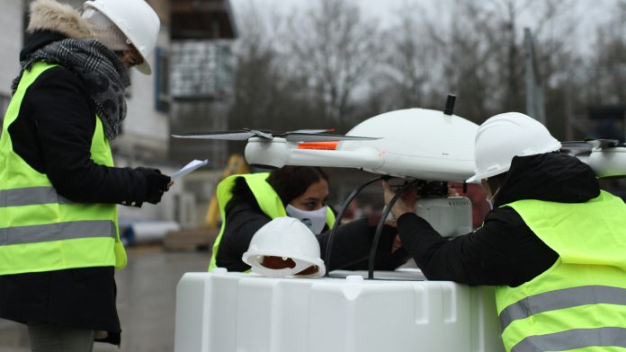
Drone technology is diverse and can be used across many different sectors. RSS-Hydro’s CEO, Dr Guy Schumann discusses the commercial and scientific applications of drones, including their geospatial uses.
In our previous articles, we reported on the use of drone technology, and its advantages and potential in various sectors, specifically in flooding and disaster response assistance. Besides the many advantages drones present to disaster management and the humanitarian aid sector, there is much to gain from using drones as a service for many other economic sectors and applications can be very diverse.
Until about five years ago, drones were mostly viewed as military devices and their market experienced a relatively slow growth due to a lack of adoption in the commercial sector. However, recent significant advancements in drone technology has allowed manufacturers to produce a wide range of models in different sizes, weights, and shapes, which can carry different sensor payloads, making them favourable across a broad application base in the commercial sector.
According to Mordor Intelligence1, the drone market is anticipated to register a compound annual growth rate (CAGR) of more than 15% during the forecast period (2021-2026) to reach USD 47.76 billion by 2025. PwC2 recently completed a socio-economic study which indicated that switching to new drone (and other aviation) technologies could be up to 48% cheaper, deliver faster journey times and improve safety compared to current methods.
With an interesting outlook on the application advantages and commercial value of the use of drones as a service, RSS-Hydro has launched its new business line RSS-Drones, offering its modular and versatile high-end drone fleet as a service to different application sectors, focusing on construction, agriculture, the environment, as well as the fast-growing energy sector.
Drone technology in the construction sector
The construction sector, including infrastructure mapping and surveillance, has the biggest drone market share and is the fastest-growing application field in the global drone market. According to Mordor Intelligence1, in 2019, the construction segment held the largest market share. In fact, in many countries, the proliferation of drones has revolutionised the operational processes in the construction industry. Digitalisation and smart drone applications based on interoperability standards, such as Building Information Models (BIM), ensure continuous and more efficient management during all phases of a construction project.
Drone technology makes data collection faster, easier, safer, and less expensive, allowing the construction sector to save money and increase productivity. Intelligent flight planning, the newest advances in 3D photogrammetry and LiDAR modelling software, as well as full integration with interoperability standards, render smart mapping and monitoring of large construction sites seamless in user workflows. Individual large infrastructure elements and smaller mobile objects can easily be extracted from a large data point cloud and rendered in an industry standard feature format for full and seamless integration with industry software packages.
Drone usage and the UN’s Sustainable Development Goals
The UN Sustainable Development Goals (SDGs) are on many people’s agenda and many businesses set them as targets in their activities. Here, drone technology can add substantial value. Agriculture for example is one of the leading application sectors in the drone market, having the ability to overcome the challenges that Precision Agriculture is now facing, linked to climate change impacts and locally sustainable and healthy production. Drone technology and services can help farmers ensure their activities are sustainable, offering, for instance, crop health and production efficiency monitoring, 3D mapping of the field, plant counting and biomass estimation to produce geotagged vegetation index maps, and other tailor-made services.
For environmental monitoring and conservation, drones can offer many benefits. They provide quick, easy, and accurate insights into many different parts of the environment, such as super-resolution terrain mapping, vegetation mapping, soil moisture monitoring, and accurate mapping of aquatic ecosystems. When combined, these applications can lead to much better and more targeted Integrated Water Resources Management (IWRM) plans to protect ecosystem services and society as a whole. Environmental applications of drones are far-reaching and in constant growth. Drones can even be used to support the prediction of floods, droughts and other hydro-meteorological risks under a changing climate, and, of course, to assist organisations in disaster response.
New drone regulations may help ensure rapid market growth
With the new European regulations for drones starting to come into force, the market of drones may grow to its full potential. Regulations will help to address many factors like security and safety concerns and scarcity of trained pilots, as well as dealing with beyond visual line of sight (BVLOS) flights, which, so far, have restrained the market to grow in many countries across the world.
References
1. Mordor Intelligence (2020) Drones Market – Growth, Trends, COVID-19 Impact, and Forecasts (2021 – 2026). Available at: https://www.mordorintelligence.com/industry-reports/drones-market
2. PwC (2021) Future Flight Challenge: socio-economic study, January 2021, UK Research and Innovation. Available at: https://www.pwc.co.uk/issues/intelligent-digital/drones/pwc-helping-shape-uk-aviation-future.html


