Scientific products must become a trusted and authoritative source to better assist flood disaster response at a global level.
It is human nature to help and assist people in need, especially the most vulnerable. This is particularly true during disasters when large areas can be hit, and many thousands of people are impacted. For flood disasters, hurricanes and tropical storms in recent years have been particularly devastating globally, with rainfall and inundation footprints far exceeding records and national response capabilities. Impacts of large-scale events have dramatically increased in recent years and their spatial coverage is oftentimes much larger than that of national ground monitoring networks, which renders response actions based on ground technologies alone ineffective.
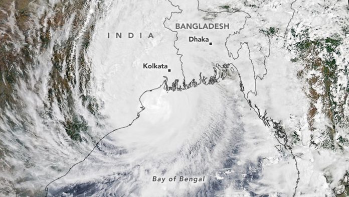
The first tropical cyclone of the 2020 season in the North Indian basin made landfall in May, delivering substantial storm surge to coastal areas (see Fig. 1). Cyclones like this are expected to become stronger with climate change effects and will put an increasing number of people at risk from extreme flooding. Effective disaster response will therefore require accurate and actionable information ever more quickly.
Innovative remote sensing technology
New remote sensing technologies (small and cube-satellites, drones), advances in Artificial Intelligence (AI), improved use of crowd-source data, social media and available census data, and interoperability standards offer promising progress in the coming years.
Because of significant advances in computing infrastructure and space technologies, earth observation-based solutions and computer models now offer ever greater capabilities to predict, monitor and map the extent of a disaster and to estimate associated impacts. This progress is considerable and has caused a shift from a traditionally data-poor environment to a data-rich environment of geospatial information.
Scientists around the world, from all types of organisations, have been increasingly stepping up to new challenges in flood monitoring and response by harnessing the full scope of remote sensing and modelling resources during events, either through ongoing activities or public (co-)funding of directly related projects. As these capabilities are designed and then progressively improved, there is a coupled need for sustainable mechanisms, especially if the number of geospatial products and services offered on a continuous basis is constantly growing.
The need for a user friendly database
For many, this is a welcomed situation offering many opportunities in academia and industry alike but for some, in particular disaster response organisations, the ‘flood’ of information may be difficult to understand and products may therefore not be allocated to a particular action, and, as a consequence, remain unused. Furthermore, the situation causes confusion to the non-expert stakeholder and products may quickly and unwillingly become an untrusted source and be considered unreliable for important decision-making. Many mandated disaster response organisations, both at the national and international level, have limited resources to make sense of the large pool of data and time is a luxury they cannot afford when responding to disasters.
The information ‘firehose’ makes it difficult to coordinate all the relevant systems during one single event. It becomes impossible with multiple simultaneous events. Although each of the response products or systems provides a unique capability, there is to date no consensus among scientists and decision-makers which EO-based flood product or service should be trusted. During an ongoing disaster, a mandated response agency can easily be faced with tens of individual flood maps that are delivered by different organisations or scientists and have been produced from the same satellite image using different classification methods. This is a common problem, which is often exacerbated by the fact that the maps rarely include any kind of accuracy statement or expected levels of uncertainty.
Naturally, this dilemma calls for a consensus among data providers about how to best create authoritative flood products or services that would be recognised as a trusted source. This would allow scientists and other producers to move their products to an operational readiness level for trusted data implementation into operation protocols of mandated disaster response organisations.


