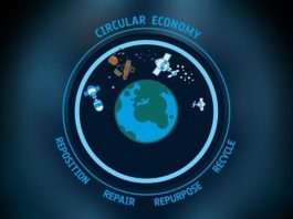
3S Northumbria aims to help develop a global space traffic management system for sustainable space use.
As the need for humanity to use space in a more sustainable and environmentally conscious fashion becomes ever more apparent, the question of how this should be achieved looms large. One key element that will be critical to sustainable space activity is a more ordered approach to the coordination and management of spacecraft orbiting the Earth.
The need for an integrated approach to dealing with the number of space objects orbiting the Earth becomes ever more pressing when considering the large numbers of so-called mega-constellations that are either being put into orbit by operators such as SpaceX or that have been authorised and are in development from private companies across the globe.
As a company with the principles of safety, security, and sustainability at its core, 3S Northumbria stands ready to assist in the development of a global system of space traffic management (STM), building upon extant international law and emerging normative behaviour. In this discussion piece, the founder of 3S Northumbria, Ralph ‘Dinz’ Dinsley, will outline the principal elements needed to establish an effective STM regime.
Tracking
Over recent years, space has become a crowded environment, with a significant increase in the number of satellites. The number of active space objects is only going to increase, thanks to the development of mega-constellations like SpaceX’s Starlink and OneWeb. As of June 2024, there are over 10,000 active satellites in orbit, and this number is expected to grow significantly.¹
Each satellite adds to the density of objects in space, increasing the likelihood of a catastrophic collision. Enhancing the global space tracking capability is an essential pre-requisite for the effective management of these assets, enabling operators to predict potential collision risks accurately and precisely.
It has long been recognised that effective space situational awareness (SSA) requires a wide range of data about the characteristics of the orbital environment. Enhancing SSA allows not only for the collision mitigation strategies but will also allow for greater transparency and confidence building measure that can lead to more stability in space. The detection, tracking and characterisation of objects in space, leading to good levels of SSA, allows for progressive approaches to space security.

Currently, space surveillance and tracking (SST) is predominantly carried out by the military, utilising systems optimised for missile warning, with only a fraction of the data collected shared through open sources to support space sustainability.
By ensuring sufficient SST out with military capabilities, the whole decision-making process that underpins any STM regime will be based on the best and most up-to-date data. The situation is slowly improving, but there still needs to be greater investment in all kinds of tracking, from radar to optical observation, across all the orbital regimes to ensure space safety and sustainability can be adequately achieved.
Persistent and robust SST sits as a cornerstone of effective STM, providing crucial data to mitigate collision risks, manage space debris and provide detailed information to support new space activities. Prioritising investment in space-tracking infrastructure will be essential to navigating the challenges of an increasingly active and congested space environment.
Data sharing
Obtaining the best data possible, as quickly as possible, on the orbital environment is foundational to an effective STM regime. Yet the ability to share that SSA data amongst all stakeholders is no less important.
If sustaining future space activities through avoiding catastrophic collisions is the primary goal of STM, then accurate and timely data sharing on the positions and trajectories of space objects is crucial for ensuring collision avoidance measures are executed precisely and effectively, whether under human direction or by means of an autonomous collision avoidance system. Ensuring that operators have access to the most up-to-date information allows informed decisions about potential avoidance manoeuvres to be made.
The international and collaborative nature of space activity naturally lends itself to the sharing of data, and yet, due to the predominance of military space tracking assets, that rarely exists. Due to the significant increase in orbital traffic, we have left behind the paradigm of ‘space is big’, and we don’t need to worry about congestion, and all stakeholders need access to the information crucial to operating safely in space.
By sharing such data widely, nations, private operators, and scientific actors can work together to provide harmonious strategies for dealing with the challenges posed by space debris and enhancing the overall safety and sustainability of human activity in outer space.
There are several ways in which data sharing for the purposes of STM might be achieved. A centralised data repository, serving as a single point of truth for all space traffic data, would be a logical first step. Current attempts at providing a catalogue for such data, whilst laudable, do not have the currency needed for effective coordination or management of space traffic.
Not only does data have to be provided comprehensively and precisely, but it must also be delivered in a timely fashion. To facilitate the sharing of data, standardised data formats and the work undertaken by bodies such as the Consultative Committee for Space Data Systems (CCSDS) are illustrative of the international space community recognising the need for interoperability not just in terms of hardware but across the entire industry.
Encouraging work is occurring across the globe, with regulators and operators alike recognising the need for increased coordination and cooperation. The US Department of Commerce is already preparing to promulgate an approach to STM that will provide much-needed leadership in this area. This discussion will now suggest one area where innovation could provide a quantum leap in the management of space traffic by utilising existing technology used to manage airspace.
A new approach: Promoting the use of IFF in space
Increased SST infrastructure and the creation of mechanisms to share the data amongst all users of space are two crucial elements of a successful STM regime. Both elements could be augmented by the integration of Identification Friend or Foe (IFF) technology. IFF is an identification system designed for command and control, which enables military and civilian air traffic control interrogation systems to identify aircraft as friendly and to determine their bearing and range from the ‘interrogator.’
Introducing it alongside increased SST could provide significant enhancements to a space traffic management regime, further mitigate against space debris, reduce the potential for harmful collisions, and improve SSA overall.
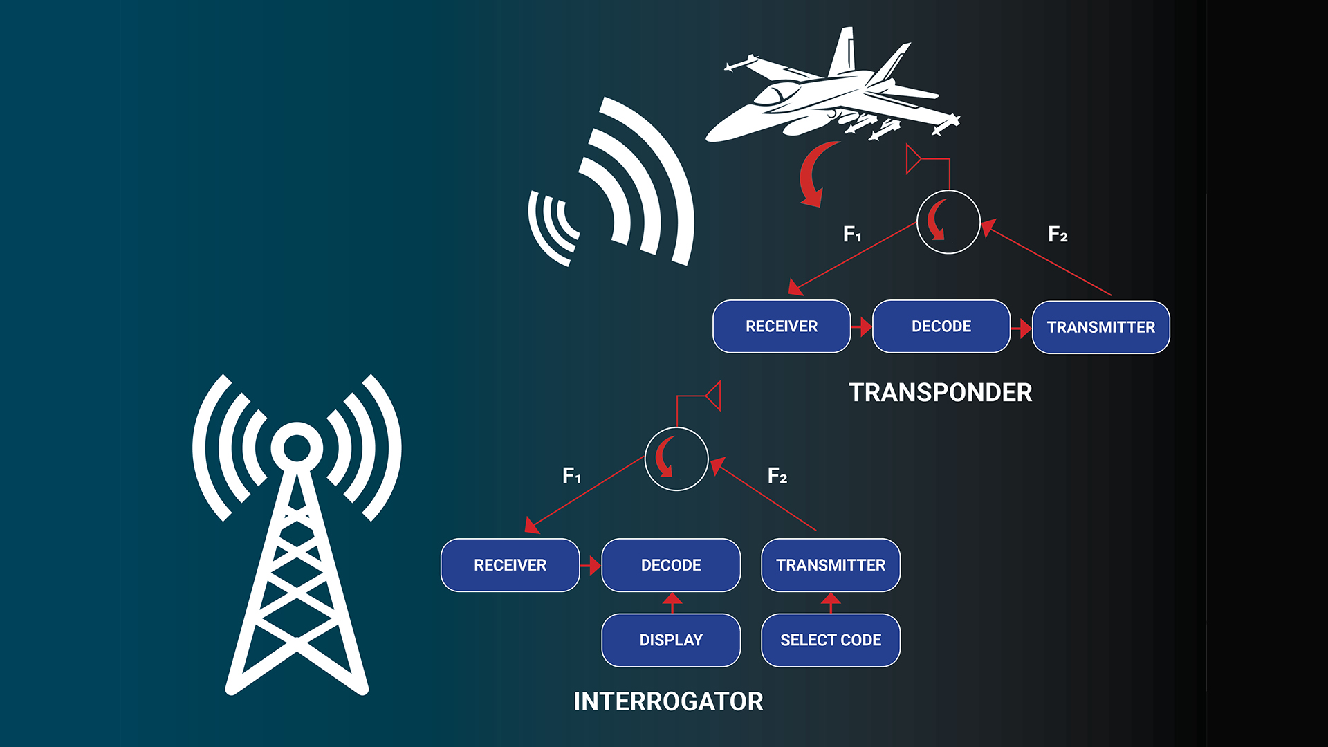
IFF technology can be traced back to the end of the Second World War, and its core principles remain very much the same to this day. The ground-based radar sends out an interrogation signal, and a transponder on the aircraft – upon receiving this – would reply with a coded identification. Upon receipt of this response, the aircraft can be identified based on that code. This allows the identification and tracking of aircraft, leading to airspace being managed in a relatively efficient and safe way.
Developing this technology for use in space could be done in the following ways. Either an interrogation signal could be transmitted by ground stations or by other satellites in orbit, or it could be operated passively with a transmitter from the satellite sending a code and positional data to be received on the ground.
Satellites would have to be equipped with transponders capable of receiving interrogation signals and sending back the appropriate identification code or transmitting the signal. If interrogated, unique identification codes and other data could then be transmitted either back to the ground stations or relayed via satellites and used for identification and tracking.
There are challenges in deploying ‘IFF for Space Objects’. First, this would be a prospective measure applying to future missions and not the 10000 operational satellites that are currently in orbit. The benefits of any IFF system would take time to percolate through. Operators would need to be convinced of the utility of such a system before committing to adding additional weight and power-hungry transponders to any satellite.
However, the opportunity exists to develop unique power sources independent of the satellite power system lightweight transponders and GPS transceivers. Additionally, the role of the regulator would be crucial in the broad acceptance of IFF for space. International standards and protocols need to be established to ensure compatibility between different companies, organisations, and nations.
Ensuring the power source for the ‘IFF for Space objects’ is independent of the satellite power system is essential to ensuring the longevity of the system. It needs to be able to transmit before a satellite is ‘operationalised on orbit’ and to continue transmitting long after the mission has been completed. Or if the mission fails to power up. The resilience of the power source is essential to ensure future debris can be tracked.
Following on from this, the transmission of signals across numerous orbital planes would require significant power and would add to an already congested electromagnetic environment. This would require close liaison with national regulators of the RF spectrum (Ofcom in the UK and the FCC in the US) and with the ITU to ensure no interference with other signals.
IFF signals could also prove a tempting target for malicious space actors to interfere with, jam or spoof, adding a layer of complexity to an already delicate security situation.
Conclusions
As the space environment becomes ever more complex and different orbits of the Earth, become increasingly more populated, so does the need for a significant increase in SST infrastructure and the sharing of data regarding the Earth’s orbit. Adapting IFF technology for use in satellites provides a significant enhancement in the capabilities for both real-time identification and tracking of space objects and long-term sustainability efforts.
The development of IFF for space would provide regulators, operators and those in the defence arena with a significant tool to deal with increasing congestion in space and ensure the transparent, safe and efficient management of space traffic. Whilst there are undoubted challenges, both technical and legal, the instigation of an IFF-style system could provide a significant step on the journey to the sustainable and secure use of outer space.
References
- In 2019, there were fewer than 2000 active satellites across all orbital regimes
Please note, this article will also appear in the 19th edition of our quarterly publication.