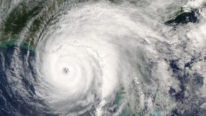
Experts from The University of Tokyo have potentially advanced early weather warning systems significantly, utilising cosmic rays to accurately monitor tropical storms for the first time.
Using the power of cosmic rays has enabled the team to analyse tropical storms in unprecedented detail, providing information that traditional visualisation techniques, such as satellite imaging, cannot and could help design more precise weather warning systems.
Increasing extreme weather events
The knock-on effects of climate change have seen a sharp rise in the prevalence of devastating storms globally, making the need for weather prediction and early warning systems all the more vital. A team from Muographix at the University of Tokyo has innovated a new method for detecting and examining tropical storms that employ the cosmic rays that occur above our heads all the time.
Professor Hiroyuki Tanaka, the leader of the research, explained: “You’ve probably seen photographs of cyclones taken from above, showing swirling vortices of clouds. But I doubt you’ve ever seen a cyclone from the side, perhaps as a computer graphic, but never as actual captured sensor data.
“What we offer the world is the ability to do just this, visualise large-scale weather phenomena like cyclones from a 3D perspective, and in real-time too. We do this using a technique called muography, which you can think of like an X-ray, but for seeing inside truly enormous things.”

How can cosmic rays detail tropical storms?
Muography is traditionally used to create X-ray images of large objects, including volcanoes, pyramids, bodies of water – and now, atmospheric weather systems. In muography, specialised sensors known as scintillators are connected to form a grid, similar to pixels on a camera sensor.
These scintillators cannot see optical light, instead seeing particles called muons created in the atmosphere when deep space cosmic rays collide with atoms in the air. Muons are special because they efficiently pass through matter without scattering as much as other particles.
However, the small amount they deviate as they pass through solid, liquid, and gaseous matter can reveal details about how they travel between the sensors and the atmosphere. Moreover, capturing a significant number of these muons passing through something can be used to create an image of it.
“We successfully imaged the vertical profile of a cyclone, and this revealed density variations essential to understanding how cyclones work,” said Tanaka. “The images show cross sections of the cyclone which passed through Kagoshima Prefecture in western Japan. I was surprised to see clearly it had a low-density warm core that contrasted dramatically with the high-pressure cold exterior. There is absolutely no way to capture such data with traditional pressure sensors and photography.”
For their study, the team employed a detector with a viewing angle of 90 degrees. The team is planning to amalgamate similar sensors to create hemispherical and omnidirectional observation stations that could be located along the length of a coastline. The additional detail provided by muography could supplement satellite data considerably, improving predictions about imminent tropical storms.
Tanaka concluded: “One of the next steps for us now will be to refine this technique in order to detect and visualise storms at different scales.
“This could mean better modelling and prediction not only for larger storm systems but more local weather conditions as well.”


